Digital elevation model (DEM) and shaded relief image of Okmok Caldera, 2010

Metadata also available as - [XML] - [Parseable text]

Frequently-anticipated questions:


What does this data set describe?

Title:
Digital elevation model (DEM) and shaded relief image of Okmok Caldera, 2010
Abstract:
In response to significant morphologic changes in Okmok Caldera due to the phreatomagmatic eruption of Okmok volcano in 2009, a new digital elevation model was acquired to document and quantitatively assess the new volcanic features and altered hydrology within the caldera.This DEM dataset provides elevation data derived from a stereo pair of Worldview-1 satellite images acquired on January 21, 2010.In addition to the DEM, a shaded-relief image is also provided for easy visualization of the data.
Supplemental_Information:
This publication is composed of both a digital elevation model (DEM) and a shaded-relief image of the Okmok Caldera. To minimize the download times, the files are offered as two separate zip files. This metadata file describes both the DEM file and the shaded-relief image. The DGGS metadata standard extends the FGDC standard to include elements that are required to facilitate our internal data management. These elements, referred to as 'layers', group and describe files that have intrinsic logical or topological relationships. The layers are named to correspond with the name of the file:
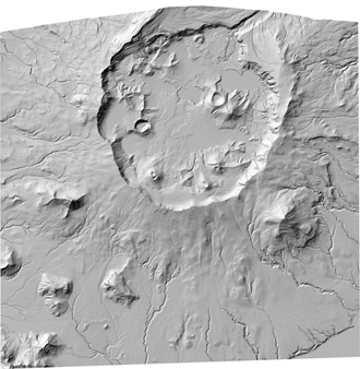
rdf2011-6-okmok-dem-21-jan2010	DEM dataset provides elevation data of the Okmok Caldera, georeferenced TIFF format (.tif and .tfw files)
rdf2011-6-okmok-shaded-relief	shaded relief image of the Okmok Caldera, georeferenced TIFF format (.tif and .tfw files)
  1. How should this data set be cited?

    Schaefer, J.R., Larsen, J.F., and Unema, J.A., 2011, Digital elevation model (DEM) and shaded relief image of Okmok Caldera, 2010: Raw Data File RDF 2011-6, State of Alaska, Department of Natural Resources, Division of Geological & Geophysical Surveys, Fairbanks, AK, USA.

    Online Links:

    Other_Citation_Details: 1 DVD

  2. What geographic area does the data set cover?

    West_Bounding_Coordinate: -168.300000
    East_Bounding_Coordinate: -167.98600000
    North_Bounding_Coordinate: 53.4890000
    South_Bounding_Coordinate: 53.2970000

  3. What does it look like?

    rdf2011-6-okmok-shaded-relief-browse.jpg
    A low resolution jpg image file derived from the higher resolution tif shaded relief image okmok_shaded_relief.tif

  4. Does the data set describe conditions during a particular time period?

    Calendar_Date: 21-Jan-2010
    Currentness_Reference: ground condition

  5. What is the general form of this data set?

    Geospatial_Data_Presentation_Form: raster digital data

  6. How does the data set represent geographic features?

    1. How are geographic features stored in the data set?

      This is a Raster data set. It contains the following raster data types:

      • Dimensions 10291 x 10045, type Grid Cell

    2. What coordinate system is used to represent geographic features?

      Grid_Coordinate_System_Name: Universal Transverse Mercator
      Universal_Transverse_Mercator:
      UTM_Zone_Number: 2
      Transverse_Mercator:
      Scale_Factor_at_Central_Meridian: 0.9996
      Longitude_of_Central_Meridian: -171.00000
      Latitude_of_Projection_Origin: 0
      False_Easting: 500000.0
      False_Northing: 0

      Planar coordinates are encoded using row and column
      Abscissae (x-coordinates) are specified to the nearest 2
      Ordinates (y-coordinates) are specified to the nearest 2
      Planar coordinates are specified in meters

      The ellipsoid used is World Geodetic System of 1984.
      The semi-major axis of the ellipsoid used is 6378137.
      The flattening of the ellipsoid used is 1/298.257223563.

      Vertical_Coordinate_System_Definition:
      Altitude_System_Definition:
      Altitude_Datum_Name: North American Vertical Datum of 1988
      Altitude_Resolution: 1.0
      Altitude_Distance_Units: meters
      Altitude_Encoding_Method: Attribute values

  7. How does the data set describe geographic features?

    rdf2011-6-okmok-dem-21-jan2010.tif
    Digital elevation model (DEM), georeferenced TIFF file (Source: this report)

    Entity_and_Attribute_Overview:
    There are no attributes other than the elevation values for the individual pixels and the encoded values for easting and northing coordinates. There are no attached attribute tables.
    Entity_and_Attribute_Detail_Citation: this report
    Overview_Description_Layer_Name: rdf2011-6-okmok-dem-21-jan2010
    rdf2011-6-okmok-shaded-relief.tif
    shaded relief image, georeferenced TIFF file (Source: this report)

    Entity_and_Attribute_Overview:
    There are no attributes other than the pixel values of 0 to 254 gray-scale for the individual pixels and the encoded values for easting and northing coordinates. There are no attached attribute tables.
    Entity_and_Attribute_Detail_Citation: this report
    Overview_Description_Layer_Name: rdf2011-6-okmok-shaded-relief


Who produced the data set?

  1. Who are the originators of the data set? (may include formal authors, digital compilers, and editors)

  2. Who also contributed to the data set?

    The original DEM was created by 'i-cubed:information integration & imaging LLC'; the initial Worldview images were provided by Rick Wessels, U.S. Geological Survey, Alaska Volcano Observatory.

  3. To whom should users address questions about the data?

    Alaska Division of Geological & Geophysical Surveys
    GIS Data Manager/GIS Analyst
    3354 College Rd
    Fairbanks, AK 99709-3707
    USA

    907-451-5029 (voice)


Why was the data set created?

The DEM dataset provides high-resolution elevation data for Okmok Caldera. The georeferenced shaded relief map of Okmok Caldera provides a basemap for visualization of new geographic features following the 2008 eruption


How was the data set created?

  1. From what previous works were the data drawn?

  2. How were the data generated, processed, and modified?

    Date: Jan-2010 (process 1 of 6)
    On January 21, 2010, DGGS-AVO acquired Worldview-1 commercial stereo satellite imagery (spatial resolution of ~1 m), 17 months after the phreatic eruption of Okmok volcano.

    Date: Aug-2010 (process 2 of 6)
    In August 2010, we surveyed image-identifiable points around the volcano using a Trimble Real Time Kinematic (RTK) Global Position System (GPS). This system provides centimeter-level horizontal and vertical accuracy.

    Date: Sep-2010 (process 3 of 6)
    We submitted six RTK surveyed points within the caldera and one point outside the caldera to the commercial vendor, ‘i-cubed: information integration and imaging LLC’, for the creation of a digital elevation model (DEM).

    Date: Dec-2011 (process 4 of 6)
    The commercial vendor, i-cubed, delivered the DEM in tif format, readable in ArcMap. We used the Copy Raster tool in ArcMap to create a new DEM, setting the NoData value to -32767. From this new DEM, we used Arc 3D Analyst (default settings of: Azimuth = 315, Altitude = 45, and Z factor = 1) to create a shaded-relief image.

    Date: Dec-2011 (process 5 of 6)
    Determination of Horizontal Accuracy: We accurately identified several point locations, based on several years of fieldwork and thus familiarity with the geographic features around Okmok volcano, combined with known locations of GPS survey sites. We made a comparison of horizontal position by plotting these known locations, along with the new DEM, in a GIS. The high-confidence, visually-identifiable points lie within 2 pixels on the DEM. The new DEM cell size is 2 meters, thus we determined the horizontal accuracy to be within 4 m.

    Date: Dec-2011 (process 6 of 6)
    Determination of Vertical Accuracy: DEM vertical accuracy assessment is complicated by the high rate of erosion and changing surface hydrology that occurred between the image acquisition date (January 21, 2010) and the RTK GPS survey seven months later (August 2010). The most significant vertical changes resulting from erosion occurred within the caldera in areas with the most ash fall. As a first step to assessing the vertical accuracy of the DEM, we used only sites outside the caldera that experienced less than 2 cm of ash fall to compare the surveyed point values to the DEM cell values. Only one RTK survey point (RTK37) and one campaign GPS site (OK29) met this criteria. The vertical cell value of the DEM minus the GPS surveyed point (delta z) are as follows: RTK37, 0.029 m; OK29, 0.490 m. Two points is not an ideal number of samples to ascertain vertical accuracy, so we considered other points within the caldera. We identified two other RTK GPS survey points (RTK29 and RTK30) near the gates along a stream channel. We compared the Worldview-1 image from Jan. 21, 2010, with a satellite image from March 31, 2010, and fieldwork in August 2010; we concluded that these two sites experienced less than 1 m of vertical erosion. Delta Z values for these two sites are: RTK29, 0.633 m; and RTK30, 0.597 m. Thus we determined a conservative vertical estimate of the accuracy of the DEM is +/- 1 m.

  3. What similar or related data should the user be aware of?


How reliable are the data; what problems remain in the data set?

  1. How well have the observations been checked?

    Attributes for the DEM are the elevation values for the individual pixels and the encoded values for easting and northing coordinates. Attributes for the shaded relief image are the elevation values for the individual pixels and the encoded values for easting and northing coordinates. See horizontal and vertical positional accuracy sections of this metadata file to learn more about the accuracy of this data.

  2. How accurate are the geographic locations?

    Based on several years of fieldwork and thus familiarity with the geographic features around Okmok volcano, in addition to known locations of GPS survey sites, there are several point locations that can be accurately identified on the new DEM surface.A comparison of horizontal position was made by plotting these known locations along with the new DEM in a GIS.See Horizontal Positional Accuracy Explanation for more details.

  3. How accurate are the heights or depths?

    Assessment of the DEM vertical accuracy is complicated by the high rate of erosion and changing surface hydrology that occurred between the image acquisition date of January 21, 2010 and the RTK GPS survey seven months later in August of 2010.The most significant vertical changes due to erosion occurred within the caldera in areas with the most ash fall.As a first step to assessing the vertical accuracy of the DEM, only sites outside the caldera that experienced less than 2 cm of ash fall were used to compare the surveyed point values to the DEM cell values. See Vertical Positional Accuracy Explanation for more details.

  4. Where are the gaps in the data? What is missing?

    The DEM coverage area is limited to the size of the original Worldview-1 image stereo pair and thus does not encompass the entire volcano and is mostly centered about the caldera.

  5. How consistent are the relationships among the observations, including topology?

    Several campaign GPS sites and RTK surveyed GPS sites were plotted in a GIS along with the DEM to ensure that both horizontal placement and vertical Z values were reasonably accurate.


How can someone get a copy of the data set?

Are there legal restrictions on access or use of the data?

Access_Constraints:
This content is available directly from the State of Alaska, Department of Natural Resources, Division of Geological &Geophysical Surveys (see contact information below).
Use_Constraints:
Any hard copies or published datasets utilizing these datasets shall clearly indicate their source. If the user has modified the data in any way, the user is obligated to describe the types of modifications the user has made. The user specifically agrees not to misrepresent these datasets, nor to imply that changes made by the user were approved by the State of Alaska, Department of Natural Resources, Division of Geological & Geophysical Surveys. The State of Alaska makes no express or implied warranties (including warranties for merchantability and fitness) with respect to the character, functions, or capabilities of the electronic data or products or their appropriateness for any user's purposes. In no event will the State of Alaska be liable for any incidental, indirect, special, consequential, or other damages suffered by the user or any other person or entity whether from the use of the electronic services or products or any failure thereof or otherwise. In no event will the State of Alaska's liability to the Requestor or anyone else exceed the fee paid for the electronic service or product.

  1. Who distributes the data set? (Distributor 1 of 1)

    State of Alaska, Department of Natural Resources, Division of Geological & Geophysical Surveys
    3354 College Road
    Fairbanks, AK 99709-3707
    USA

    907-451-5020 (voice)
    907-451-5050 (FAX)
    dggspubs@alaska.gov

    Hours_of_Service: 8 am to 4:30 pm, Monday through Friday, except State holidays
    Contact_Instructions:
    Please view our website (<http://www.dggs.alaska.gov>) for the latest information on available data. Please contact us using the e-mail address provided above when possible.
  2. What's the catalog number I need to order this data set?

    RDF 2011-6

  3. What legal disclaimers am I supposed to read?

    The State of Alaska makes no express or implied warranties (including warranties of merchantability and fitness) with respect to the character, function, or capabilities of the electronic services or products or their appropriateness for any user's purposes. In no event will the State of Alaska be liable for any incidental, indirect, special, consequential, or other damages suffered by the user or any other person or entity whether from the use of the electronic services or products, any failure thereof, or otherwise, and in no event will the State of Alaska's liability to the requester or anyone else exceed the fee paid for the electronic service or product.

  4. How can I download or order the data?


Who wrote the metadata?

Dates:
Last modified: 30-Dec-2011
Metadata author:
Metadata manager
3354 College Road
Fairbanks, AK 99709-3707
USA

907-451-5020 (voice)

Metadata standard:
FGDC Content Standard for Digital Geospatial Metadata (FGDC-STD-001-1998)
Metadata extensions used:


Generated by mp version 2.9.6 on Fri Dec 30 13:48:34 2011