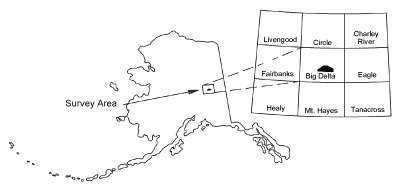
Burns, L.E., Barefoot, J.D., Naibert, T.J., Fugro Airborne Surveys Corp., and Stevens Exploration Management Corp., 2019, Goodpaster electromagnetic and magnetic airborne geophysical survey data compilation: Alaska Division of Geological & Geophysical Surveys Geophysical Report 2018-4, 3 p. https://doi.org/10.14509/29813
 Report Information
 Geospatial & Analytical Data
Aeromagnetic; Aeromagnetic Data; Aeromagnetic Map; Aeromagnetic Survey; Airborne Geophysical Survey; Analytic Signal; Apparent Resistivity Contours; Apparent Resistivity Data; Apparent Resistivity Map; Apparent Resistivity Survey; Big Swede Creek; Central Creek; Conductivity Survey; Corda Creek; DIGHEM-V EM System; Differential Depth; Differential Resistivity; Eagle Creek; Electromagnetic Anomalies; Electromagnetic Data; Electromagnetic Data Inversion; Electromagnetic Survey; Exploration; Frequency Domain Electromagnetic Data; Geologic; Geology; Geophysical Map; Geophysical Survey; Geophysics; Geophysics Search Tag; Goodpaster Mining District; Goodpaster River; Gridded Data; Helicopter Survey; Induced Polarization; Inversion; Line Data; Magnetic Contours; Magnetic Data; Magnetic Survey; Magnetics; Modeling; Radiometric Survey; Radiometrics; Remote Sensing; Resistivity; Resistivity Model; Resistivity Survey; Sand Creek; Sevenmile Creek; Shaw Creek Dome; Sonora Creek; Stacked Multi-Channel Profiles; Tenmile Creek; White Creek; geoscientificInformation