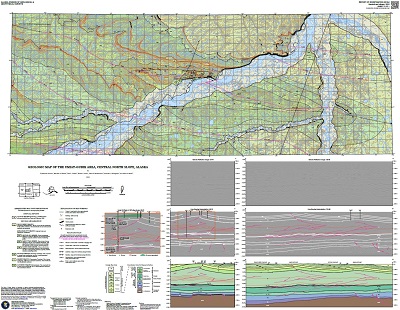
Herriott, T.M., Wartes, M.A., Decker, P.L., Gillis, R.J., Shellenbaum, D.P., Willingham, A.L., and Mauel, D.J., 2018, Geologic map of the Umiat-Gubik area, central North Slope, Alaska: Alaska Division of Geological & Geophysical Surveys Report of Investigation 2018-6, 55 p., 1 sheet, scale 1:63,360. https://doi.org/10.14509/30099
 Report Information
 Maps & Other Oversized Sheets
 Geospatial & Analytical Data
These data products comply with our published AK GeMS standard. Download the ak_gems_db product to receive the full AK GeMS database and associated files. Download the gems_db (a.k.a. fed_gems_db) product to receive the data converted into the GeMS standard published by the USGS. Download the gems_shp (a.k.a. fed_gems_shp) product to receive simple shapefile representations of the data. For further information see the AK GeMS Database Project Page.
| Geologic map of the Umiat-Gubik area, central North Slope | Data File Format | File Size | Info |
|---|---|---|---|
| Download ri2018_006_umiat_ak_gems_db_pkg | Vector data | 14.3 M | Metadata - Read me |
| Download ri2018_006_umiat_gems_db_pkg | Vector data | 13.7 M | Metadata - Read me |
| Download ri2018_006_umiat_gems_shapefile_pkg | Shapefile | 1.1 M | Metadata - Read me |
Alluvial Deposits; Anaktuvuk River; Barrow Trail Member; Bearpaw Creek; Bentonite; Brookian; Brookian Sequence; Brooks Range; Campanian; Cenomanian; Chandler River; Colville Basin; Colville River; Coniacian; Cretaceous; DGGS; Energy; Folds; Foreland Basin; Formations; Fossil Creek; Fracture; GeMS DB L3 Compliant; GeMS DB v1pt1; Geologic; Geologic Map; Gubic Gas Field; Henry Creek; Hydrocarbon; Kakiagun Lake; Kikiakrorak River; Kogosukruk River; Kutchik River; Maastrichtian; Mudstone; Nanushuk Formation; North Slope; Oil and Gas; Outcrop Samples; Petroleum; Prince Creek; Prince Creek Formation; Quaternary; Rainy Creek; Roger Creek; Rogers Creek Member; STATEMAP Project; Sandstone; Santonian; Schrader Bluff Formation; Seabee Creek; Seabee Formation; Sedimentary Rocks; Seismic Interpretation; Sentinel Hill Member; Sequence Stratigraphy; Shivugak Bluff; Siltstone; Surficial Geology; Tattitgak Bluff; Tuluvak Formation; Turonian; Umiat; Umiat Lake; Umiat Mountain; geoscientificInformation


