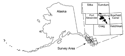
Burns, L.E., Graham, G.R.C., Barefoot, J.D., and WGM Mining and Geological Consultants, Inc., 2020, Stikine electromagnetic and magnetic airborne geophysical survey data compilation: Alaska Division of Geological & Geophysical Surveys Geophysical Report 2020-11, 15 p. https://doi.org/10.14509/30457
 Report Information
 Geospatial & Analytical Data
| Stikine geophysical survey | Data File Format | File Size | Info |
|---|---|---|---|
| Download gpr2020_011_stikine_1997_ascii_data | ASCII tabular files | 60.0 M | Metadata - Read me |
| Download gpr2020_011_stikine_1997_databases_geosoft | Linedata Geosoft format database | 56.5 M | Metadata - Read me |
| Download gpr2020_011_stikine_1997_documents | Adobe PDF files | 7.3 M | Metadata - Read me |
| Download gpr2020_011_stikine_1997_grids_ermapper | Gridded data ER Mapper | 7.7 M | Metadata - Read me |
| Download gpr2020_011_stikine_1997_grids_geosoft | Gridded data Geosoft format | 7.9 M | Metadata - Read me |
| Download gpr2020_011_stikine_1997_images_registered | Image files | 8.9 M | Metadata - Read me |
| Download gpr2020_011_stikine_1997_kmz | Google Earth files | 68.8 M | Metadata - Read me |
| Download gpr2020_011_stikine_1997_maps_pdf_format | Adobe PDF files | 2.6 G | Metadata - Read me |
| Download gpr2020_011_stikine_1997_vector_data | Vector data | 68.9 M | Metadata - Read me |
Aaron Creek; Aeromagnetic; Aeromagnetic Data; Aeromagnetic Map; Aeromagnetic Survey; Airborne Geophysical Survey; Alice Peak; Analytic Signal; Apparent Resistivity Data; Apparent Resistivity Map; Apparent Resistivity Survey; Baht Harbor; Bains Cove; Barrie Lake; Battery Islets; Beecher Pass; Berg Creek; Berg Mountain; Big Castle Island; Big Creek; Big John Creek; Big Saltery Island; Blowdown Island; Bohemian Range; Burnett Lake; Burnt Island; Butterworth Island; Castle Islands; Castle River; Cathedral Falls Creek; Christmas Island; Cloverleaf Island; Colorado Creek; Conductivity Survey; Deadman Island; Dry Cove; Duncan Canal; Duncan Creek; Electromagnetic Data; Electromagnetic Survey; Emily Island; Exploration; Fair Island; First Vertical Derivative; Frederick Sound; Frequency Domain Electromagnetic Data; Fritter Cove; Geologic; Geology; Geophysical Map; Geophysical Survey; Geophysics; Geophysics Search Tag; Glacier Creek; Gridded Data; Grief Island; Hamilton Creek; Harbor Island; Harrys Lake; Harvey Lake; High Castle Island; Independence Island; Irish Creek; Jewell Island; Kah Sheets Creek; Kah Sheets Island; Kah Sheets Lake; Keating Range; Keene Channel; Keene Island; Keku Creek; Kupreanof Island; Kushneahin Creek; Kushneahin Lake; Lava Creek; Line Data; Little Baht Harbor; Little Saltery Island; Lovelace Creek; Lung Island; Magnetic Data; Magnetic Survey; Magnetics; Marsha Peak; Middle Creek; Mosman Island; Moss Island; Mount Waters; Navy Lake; Nelson Glacier; Pearl Island; Porcupine Creek; Porterfield Creek; Quiet Harbor; Remote Sensing; Resistivity; Resistivity Survey; Rookery Island; Roosevelt Harbor; Saint John Harbor; Salmon Creek; Southerly Island; Spirit Creek; Taylor Creek; Towers Lake; Tunehean Creek; Whiskey Pass; Woewodski Island; Woodpecker Cove; Wrangell Narrows; Zarembo Island; geoscientificInformation


