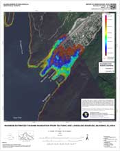
Nicolsky, D.J., Suleimani, E.N., and Salisbury, J.B., 2018, Tsunami inundation maps for Skagway and Haines, Alaska: Alaska Division of Geological & Geophysical Surveys Report of Investigation 2018-2, 69 p., 3 sheets. https://doi.org/10.14509/30029
 Report Information
 Maps & Other Oversized Sheets
 Geospatial & Analytical Data
| Tsunami inundation data of Skagway and Haines | Data File Format | File Size | Info |
|---|---|---|---|
| Download ri2018_002_tsunami-inundation-skagway-haines | Shapefile | 1.7 M | Metadata - Read me |
Active Fault; Anchorage Point; Bathymetry; Battery Point; Chilkat Inlet; Chilkat Peninsula; Chilkoot Inlet; Coastal; Coastal and River; Dalasuga Island; Dayehas Creek; Deshu Isthmus; Dyea Point; Earthquake; Earthquake Related Slope Failure; Emergency Preparedness; Engineering; Engineering Geology; Environmental; False Battery Point; Fault Displacement; Faulting; Faults; Ferebee River; Ferebee Valley; Flood; Geologic; Geologic Hazards; Geological Process; Geology; geoscientificInformation; Geotechnical; Glacier Point; Green Point; Haines; Haska Creek; Hazards; Holocene; Indian Rock; Inundation; Jenkins Rock; Kalhagu Cove; Kaskulu Point; Katzehin River; Kelgaya Bay; Kelgaya Point; Kochu Island; Land Subsidence; Landslide; Lehunua Island; Lehunua Point; Letnikof Cove; Lily Lake; Low Point; Ludaseska Creek; Lutak Inlet; Marine Geology; McClellan Flats; Mink Creek; Modeling; Mount Riley Trail; Mount Ripinski; Nahku Bay; Nahku Portage; Neotectonics; Nukdik Point; Paradise Cove; Port Chilkoot; Portage Cove; Pyramid Harbor; Rustabach Lake; Seduction Point Trail; Seismic Hazards; Shiyi Bay; Skagway; Skagway River; Slides; Slope; Slope Instability; Slump; Smugglers Cove; Subsidence; Surface; Taiya Point; Taiya River; Taiyasanka Harbor; Tanani Bay; Tanani Beach; Tanani Point; Tanani Village; Tectonics; Tides; Tlegu Beach; Topography; Tsunami; Yakutania Point; Yindastuki


