DGGS GPR 2019-6
Council electromagnetic and magnetic airborne geophysical survey data compilation
Authors:
Burns, L.E., Barefoot, J.D., and Stevens Exploration Management Corp.Publication Date:
Apr 2019Publisher:
Alaska Division of Geological & Geophysical Surveys Comments:
Supersedes GPR 2003-1, GPR 2003-1-1A, GPR 2003-1-1B, GPR 2003-1-1C, GPR 2003-1-1D, GPR 2003-1-2A, GPR 2003-1-2B, GPR 2003-1-2C, GPR 2003-1-2D, GPR 2003-1-2E, GPR 2003-1-2F, GPR 2003-1-3A, GPR 2003-1-3B, GPR 2003-1-3C, GPR 2003-1-4A, GPR 2003-1-4B, GPR 2003-1-4C, GPR 2003-1-5A, GPR 2003-1-6A, GPR 2003-2, GPR 2003-3, and GPR 2003-4.Ordering Info:
Download below for free or see our publication sales page to order a hard copy.
Quadrangle(s):
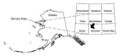
Bendeleben; SolomonRelated project(s):
Council geophysicsSupersedes:
GPR 2003-1, GPR 2003-1-1A, GPR 2003-1-1B, GPR 2003-1-1C, GPR 2003-1-1D, GPR 2003-1-2A, GPR 2003-1-2B, GPR 2003-1-2C, GPR 2003-1-2D, GPR 2003-1-2E, GPR 2003-1-2F, GPR 2003-1-3A, GPR 2003-1-3B, GPR 2003-1-3C, GPR 2003-1-4A, GPR 2003-1-4B, GPR 2003-1-4C, GPR 2003-1-5A, GPR 2003-1-6A, GPR 2003-2, GPR 2003-3, GPR 2003-4Citation ID:
30172
Bibliographic Reference
Burns, L.E., Barefoot, J.D., and Stevens Exploration Management Corp., 2019, Council electromagnetic and magnetic airborne geophysical survey data compilation: Alaska Division of Geological & Geophysical Surveys Geophysical Report 2019-6, 3 p. https://doi.org/10.14509/30172
Publication Products
-
 Report Information
-
 Geospatial & Analytical Data
Keywords
Aeromagnetic; Aeromagnetic Data; Aeromagnetic Map; Aeromagnetic Survey; Airborne Geophysical Survey; Analytic Signal; Apparent Resistivity Data; Apparent Resistivity Map; Apparent Resistivity Survey; Bear River; Big Hurrah Mine; Casadepaga River; Conductivity Survey; Council Mining District; Donahue Mountain; Electromagnetic Data; Electromagnetic Survey; Exploration; First Vertical Derivative; Fox River; Frequency Domain Electromagnetic Data; Geologic; Geology; Geophysical Map; Geophysical Survey; Geophysics; Geophysics Search Tag; geoscientificInformation; Gridded Data; Klokerblok River; Kougarok Mining District; Line Data; Magnetic Data; Magnetic Survey; Magnetics; Mount Dixon; Mount Mordaunt; Niukluk River; Nome Mining District; Remote Sensing; Resistivity; Resistivity Survey; Seward Peninsula; Skookum River; Solomon River; Topkok River
Top of Page

 Report Information
 Geospatial & Analytical Data