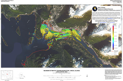
Nicolsky, D.J., Suleimani, E.N., Koehler, R.D., and Salisbury, J.B., 2017, Tsunami inundation maps for Juneau, Alaska: Alaska Division of Geological & Geophysical Surveys Report of Investigation 2017-9, 66 p., 5 sheets. https://doi.org/10.14509/29741
 Report Information
 Maps & Other Oversized Sheets
 Geospatial & Analytical Data
| Tsunami inundation maps of Juneau | Data File Format | File Size | Info |
|---|---|---|---|
| Download ri2017_009_juneau-tsunami-inundation-maps | data compilation | 45.5 M | Metadata - Read me |
Bathymetry; Berners Bay; Coastal; Douglas; Douglas Island; Eagle River; Earthquake; Engineering; Environmental; Faults; Favorite Channel; Flood; Fritz Cove; Geologic; Geology; geoscientificInformation; Geotechnical; Hazards; Inundation; Juneau; Landslide; Marine; Mendenhall River; Modeling; Regional; Rockfall; Saginaw Channel; Sediment; Sedimentation; Sheep Creek; Slides; Slope; Slump; Southeast Alaska; Subduction; Subsidence; Surface; Taku Inlet; Tectonics; Topography; Tsunami; Uplift; Water


