DGGS MP 167
Map and database of exploration drilling targets categorized by play type, North Slope and offshore Arctic Alaska
Authors:
Gregersen, Laura, and Brown, GarrettPublication Date:
Oct 2021Publisher:
Alaska Division of Geological & Geophysical Surveys Print Price:
$53.50Ordering Info:
Download below for free or see our publication sales page to order a hard copy.
Quadrangle(s):
Barrow; Barter Island; Beechey Point; Chandler Lake; De Long Mountains; Flaxman Island; Harrison Bay; Ikpikpuk River; Killik River; Lookout Ridge; Meade River; Mount Michelson; Point Lay; Sagavanirktok; Teshekpuk; Umiat; Utukok River; WainwrightRelated project(s):
North SlopeCitation ID:
30579
Bibliographic Reference
Gregersen, Laura, and Brown, Garrett, 2021, Map and database of exploration drilling targets categorized by play type, North Slope and offshore Arctic Alaska: Alaska Division of Geological & Geophysical Surveys Miscellaneous Publication 167, 15 p., 4 sheets, scale 1:725,000. https://doi.org/10.14509/30579
Publication Products
-
 Report Information
-
 Supplemental File(s)
-
 Maps & Other Oversized Sheets
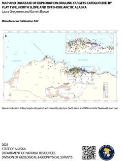
- Sheet 1, Map and database of exploration drilling targets categorized by play type, North Slope and offshore Arctic Alaska, scale 1:725,000 (6.0 M)
- Sheet 2, Maps of Ellesmerian, Sadlerochit Group, Kekiktuk Formation and Lisburne Group, Sag River Formation and Shublik Formation targets, North Slope and offshore Arctic Alaska, scale 1:725,000 (3.0 M)
- Sheet 3, Maps of Cretaceous rift and Jurassic shoreface targets, North Slope and offshore Arctic Alaska, scale 1:725,000 (3.0 M)
- Sheet 4, Maps of Brookian topset and Brookian turbidite targets, North Slope and offshore Arctic Alaska, scale 1:725,000 (3.0 M)
-
 Geospatial & Analytical Data
Keywords
DGGS
Top of Page