To facilitate mineral exploration and development in Alaska, this document provides links to geoscience, GIS, and minerals-related data, as well as
permitting, claims, and land status information. It also describes agency roles and provides key contacts.
Alaska Division of Geological & Geophysical Surveys
The Alaska Division of Geological & Geophysical Surveys (DGGS) provides geophysical, geological, geochemical,
mineral-resource, and other publications, databases, and datasets to help guide industry mineral exploration in Alaska.
Geologic Publications & Data
DGGS Publications, Maps, Geospatial Data, & Research
- DGGS publications
- Search for Alaska publications from DGGS, USGS, and other sources
- Alaska Geologic Data Index
- Search AGDI for unpublished geologic data; also includes all records from the database formerly known as AKMIDI
- Interactive Maps
- Elevation, geologic maps, geochemistry, geophysics, etc.
- Mineral Resources Section
- Current DGGS geologic mapping and mineral-resource studies
USGS Publications, Maps, Geospatial Data, & Research
- MRData Alaska
- Mineral Resources Online Spatial Data: Interactive maps and downloadable data for regional and global geology, geochemistry, geophysics, and mineral resources.
- Publications Warehouse
- Comprehensive listing of USGS publications.
- USGS Alaska geologic and mineral-resource research
- Provides links to current USGS mineral resources studies.
- Science Portal
- A searchable, web map-based tool to facilitate access to information on USGS studies in Alaska.
U.S. Bureau of Land Management (BLM) Publications
- Technical and Open File Reports - includes mining district studies
- U.S. Bureau of Mines Reports
Geochemical Data
- DGGS Alaska Geochemistry
- Interactive database of geochemical data, which may be searched for select analyses, or all data may be downloaded by searching on '*'. Original publication links and analytical information are included.
- Alaska Geochemical Database, V.2 (AGDB2)
- Downloadable database containing more than 250,000 rock, soil, stream sediment, and heavy mineral samples collected by various agencies between 1962 and 2009. It includes a 'best value' for each element to simplify use. NOTE: An updated version (AGDB3) is being planned for release in early 2019.
- Interactive Maps
- The USGS modeled and mapped the distributions of 68 elements, creating an updated Geochemical Atlas of Alaska. It includes sediment and soil geochemical data with an average sample site density of approximately 1 locality per 10 square kilometers.
Geophysical Data
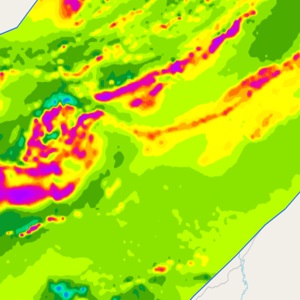
DGGS hosts a variety of geophysical data to support mineral exploration including airborne magnetic, electromagnetic, and radiometric data. Project scale, regional, and statewide are available
from the Get Data page. To learn more, please see the Geophysics Program overview.
- Geophysics program overview
- Get geophysical data
- Geophysical data interactive map
Geologic Map Data
- DGGS Geologic Map Index of Alaska
- This Interactive Map application provides outlines of DGGS and USGS geology related maps of Alaska for selection and download. Click on the "More Options" button to enable easier searching.
- USGS Regional Geologic Map of Alaska
- Includes both a statewide geologic map (print, PDF, and ArcGIS versions) and an integrated digital compilation of published and unpublished 1:250,000-scale and limited 1:500,000- to 1:63,360-scale maps in ArcGIS format. Publication also contains a statewide compilation of geochronology data.
Mineral Occurrence Data
- Alaska Resource Data File (ARDF)
- Current, comprehensive database describing Alaska's mines, prospects, and mineral occurrences, in Excel or FileMaker Pro formats.
Also, an ARDF online search is available, but may not contain the most recent updates.
Remote Sensing, Imagery, & Ortho-photos
- USGS Earth Explorer
- Aerial imagery, ASTER, Landsat, satellite, etc.
- USGS ScienceBase Catalog
- Search site for USGS maps, data, publications, and digital datasets.
- University of Alaska Fairbanks (UAF) HyLab (Hyperspectral Imaging) Laboratory
- Custom hyperspectral surveying for mineral exploration in Alaska.
- USGS LandsatLook Viewer
- LandsatLook Viewer allows rapid online viewing and access to USGS Landsat image archives. Also available through ESRI.
- Alaska Geospatial Imagery Services
- The State of Alaska took over GeoNorth services and GINA datasets formerly at University of Alaska Fairbanks.
Permitting, Claims, Land Status, & GIS Data

- Alaska Mapper
- Interactive, downloadable access to the State of Alaska's GIS files (e.g., infrastructure, physiographic features, land status/ownership/use, land records, mining claims, Public Land Survey System (PLSS) data, quadrangle boundaries, etc).
- DNR and DNR Plats and Surveys
- Locate, research, and verify land ownership and land use on state and federal lands in Alaska. Access state and federal plats and survey documents.
- DNR Land Administration System (LAS)
- DNR case file and land abstracts, useful for researching claim ownership.
- DNR Online Payments
- Make a State mining claim payment.
- DNR Division of Mining, Land, & Water Applications and Forms
- State mining claim-related forms.
- DNR Recorder's Office
- The authoritative source for Alaska's public records and land status documents.
- U.S. Bureau of Land Management (BLM) Spatial Data Management System (SDMS)
- Map interface for generalized and detailed land status and Federal mining claims.
- U.S. BLM General Land Office Records
- Live access to Federal land-conveyance records for the Public Land States, includes federal land patents, survey plats and field notes, and land status records.
Sample Repository, Historical Data Archives, & Libraries
- DGGS Geologic Materials Center (GMC)
- Central repository for archived geologic materials collected in Alaska by industry, state and federal agencies, and others. Materials are digitally cataloged, stored, and made publically available for study.
- Alaska Minerals Information System (AMIS) files
- The Minerals Availability System (MAS) is a historical U.S. Bureau of Mines database used to monitor supply potential of minerals considered essential to the U.S. industrial base, including identification of major mineral deposits, evaluation of their resources, and production. Hard copies of files are available at Alaska Resources Library and Information Services (ARLIS) in Anchorage.
- Kardex Mineral Property Records
- Alaska Mineral Property Kardex Images and Index Maps: by 1:250,000 Quadrangle.
The Kardex files were a paper-based system developed by the Territory of Alaska in 1953 to track minerals information and mining activity. Files contain historical information on production, mining methods, and individuals involved. Through the mid-1990's, the U.S. Bureau of Mines maintained a series of overlays at 1:250,000 scale showing Kardex locations and property descriptions.
- Alaska Mineral Industry Data Index (AKMIDI)
- Database of ~16,000 records of mineral information that are owned by ~18 different groups around the state, including Native corporations, private companies, state libraries, and land managers.
- Alaska Resource Library and Information Service (ARLIS)
- ARLIS is a repository for State and Federal mineral-resource information and private collections; includes Anaconda Minerals Co. collection (outside CIRI region). Reference Services, Anchorage, AK, 99509; PH: (907) 272-7547
- Alaska-Related Master's Theses and Ph.D. Dissertations
- An annotated bibliography of Alaska-related Master's theses and Ph.D. dissertations.
Miscellaneous Links
- Alaska Mineral Industry Report
- An annual summary of mineral activity (mining, advanced projects, exploration) in Alaska.
- Alaska's Mineral Resources Poster
- A poster-sized map showing the locations of exploration projects and mines in Alaska.
- Alaska Miners Association (AMA)
- Trade association for mineral exploration and mining in Alaska. AMA offers a number of industry resources on its website, hosts annual conferences, and publishes an annual directory of Alaska exploration service companies and consultants.
- Alaska Native Corporations
- The Alaska Native Claims Settlement Act (ANCSA), enacted into law December 18, 1971, was intended to settle outstanding land claims and establish clear title to Alaska's land and resources. The Act established Native regional and village (community) corporations.
DNR maintains a map of Alaska Regional Corporation boundaries.


