A volcano is a vent in the Earth's crust, the outer layer of the Earth. Volcanoes contain magma and gas. When magma erupts on the surface of the Earth, it is called lava. The two main types of volcanoes are shield volcanoes and stratovolcanoes. Shield volcanoes, such as Kīlauea volcano in Hawai'i, often erupt lava flows, whereas stratovolcanoes, such as Cleveland volcano in Alaska, often erupt more explosively.
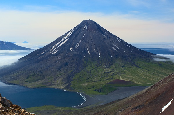
Cleveland Volcano seen from the western end of Tana Volcano. Photo taken during the Islands of Four Mountains multidisciplinary project, work funded by the National Science Foundation, the USGS/AVO, and the Keck Geology Consortium. Photo credit: John Lyons, AVO/USGS, taken August 5, 2015. (AVO image ID 80271)
A volcanologist is a special type of geologist, one who focuses on the study of volcanoes! Volcanologists study characteristics of volcanoes, both active and inactive, in order to better understand the processes that occur at volcanoes and better anticipate how volcanoes may behave in the future.
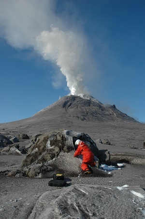
A volcanologist recovers a monitoring instrument on Augustine volcano, Alaska. Photo credit: R.G. McGimsey, AVO/USGS, taken March 10, 2006. (AVO image ID 8685)
Volcanologists study the physical characteristics of a volcano, such as the rocks and minerals that form lava, lava chemistry, and how volcanic deposits are formed and preserved on the Earth's surface. Volcanologists also study geophysical characteristics, such as earthquakes, and geodetic characteristics, such as changes in the shape of the Earth (inflation and deflation) due to magma movement.
Most of the volcanoes in Alaska are in remote locations that are difficult to reach, so the scientists at the Alaska Volcano Observatory (AVO) monitor the volcanoes remotely. How is a volcano monitored remotely? At AVO we use satellite images to look for warm ground or to track ash clouds. We setup seismic instruments on the volcanoes with a special radio transmitter that sends earthquake data to our offices in Anchorage and Fairbanks. Scientists also conduct fieldwork by helicopter for mapping, sample collection, and eruption observations. The scientists working at the Alaska Volcano Observatory have many challenges, a few of which are bad weather, bears, and lots of snow! Check out our pictures.


