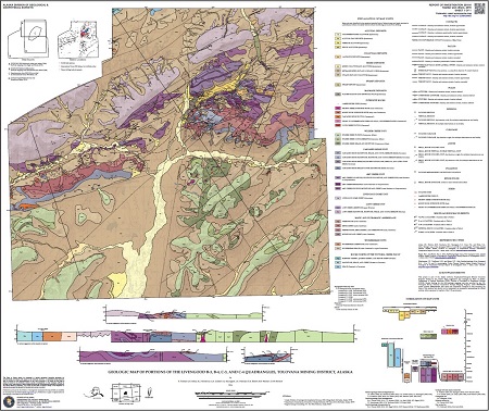
Twelker, Evan, Athey, J.E., Newberry, R.J., Griesel, G.A., Szumigala, D.J., Freeman, L.K., Elliott, B.A., Werdon, M.B., and Stevens, D.S.P., 2016, Geologic map of portions of the Livengood B-3, B-4, C-3, and C-4 quadrangles, Tolovana mining district, Alaska: Alaska Division of Geological & Geophysical Surveys Report of Investigation 2016-5, 39 p., 1 sheet, scale 1:50,000. https://doi.org/10.14509/29665
 Report Information
 Maps & Other Oversized Sheets
 Geospatial & Analytical Data
These data products comply with our published AK GeMS standard. Download the ak_gems_db product to receive the full AK GeMS database and associated files. Download the gems_db (a.k.a. fed_gems_db) product to receive the data converted into the GeMS standard published by the USGS. Download the gems_shp (a.k.a. fed_gems_shp) product to receive simple shapefile representations of the data. For further information see the AK GeMS Database Project Page.
| Geologic map of portions of the Livengood B-3, B-4, C-3, and C-4 quadrangles | Data File Format | File Size | Info |
|---|---|---|---|
| Download ri2016_005_livengood_geologic_2016_ak_gems | Vector data | 14.8 M | Metadata - Read me |
| Download ri2016_005_livengood_geologic_2016_gems | Vector data | 15.1 M | Metadata - Read me |
| Download ri2016_005_livengood_geologic_2016_gems_shapefile | Shapefile | 2.1 M | Metadata - Read me |
| Livengood Ar/Ar | |||
| Download ri2016_005_livengood-ar-ar | ASCII tabular files | 24.5 K | Metadata - Read me |
40Ar/39Ar; Actinolite; Airborne Geophysical/Geological Mineral Inventory; Alabam Creek; Alluvial; Alluvium; Amy Creek; Amy Creek Assemblage; Amy Dome; Apatite; Argillite; Basalt; Bedrock; Bedrock Geology; Bridge Creek; Brooks Creek; Brown Lake; Cambrian; Cascaden Ridge; Cascaden Ridge Unit; Cenozoic; Chalcedony; Chalcopyrite; Chemistry; Chert; Chlorite; Chrysotile; Claystone; Cleary Creek; Colluvium; Conglomerate; Conodonts; Copper; Cretaceous; Crinoids; Devonian; DGGS; Dolomite; Dolostone; Dome; Dominion Creek; Eagle Creek; Eolian; Epidote; Erickson Creek; Erosion; Ester Creek; Exploration; Feldspar; Felsic; Fluvial; Flysch; Folding; Fossils; Fracture; Fracturing; Franklin Creek; Gabbro; Gelifluction; GeMS DB L3 Compliant; GeMS DB v1pt1; Geochemistry; Geochronology; Geologic Map; Geology; Georgie Creek; geoscientificInformation; Gertrude Creek; Gold; Goldstream Creek; Granite; Granodiorite; Graptolites; Gravel; Graywacke; Greenschist; Greenstone; Heine Creek; Holocene; Hornblende; Igneous; Igneous Rocks; Iron; Isabell Creek; Labradorite; Lamprophyre; Landslide; Lillian Creek; Limestone; Livengood; Livengood Bench; Livengood Creek; Livengood Dome; Livengood Dome Chert; Livengood Terrane; Loess; Lost Creek; Lost Creek Unit; Lucille Creek; Lucky Creek; Magnetite; Malachite; Man-Made Deposits; Manganese; Martin Creek; Mesozoic; Metamorphic; Metamorphic Rocks; Mica; Miller Creek; Mineralogy; Minerals; Mississippian; Money Knob; Monzonite; Mudstone; Muscovite; Myrtle Creek; Olive Creek; Ordovician; Paleozoic; Permian; Phyllite; Pingos; Placer; Plagioclase; Pleistocene; Pliocene; Plutonic Rocks; Plutons; Porphyry; Prehnite; Proterozoic; Pyrite; Pyrrhotite; Quartz; Quartzite; Quaternary; Rampart Group; Rampart Mining District; Ranney Hollow; Ready Bullion Creek; Rhyolite; Rocks; Rosebud Creek; Ruth Creek; Sand; Sandstone; Sedimentary; Sedimentary Rocks; Sericite; Serpentinite; Shale; Shorty Creek; Silt; Siltstone; Silurian; Silver; Slate; Slate Creek; STATEMAP Project; Steel Creek; Stratiform; Surface; Surficial Geology; Syenite; Tailings; Talc; Tatalina River; Terrace; Tertiary; Thermokarst; Tolovana Mining District; Tolovana River; Triassic; Tuff; Turbidite; Turbidites; Ultramafic; Victoria Creek Fault; Vigor Creek; Volcanic; Wackestone; Wickersham Unit; Wilber Creek; Wilber Creek Unit; Willow Creek; Winter Creek; Wonder Creek; Zircon


