Geophysical data is used to provide information on the physical properties of the Earth's surface and subsurface. As a result, geophysical data can help locate hydrocarbons, minerals, aggregate, and other natural resources. Geophysical data can also be used for geologic mapping, hydrology, environmental monitoring, slope stability assessment, infrastructure planning and monitoring, and to study permafrost.
DGGS, mineral explorers, and other organizations and individuals use geophysical data to assist in geologic mapping, determine the mineral potential of a region, and locate mineral deposits. Magnetic data can differentiate and map geologic units, locate magnetic intrusions, indicate faults, and show areas of alteration. Electromagnetic data can be used to differentiate and map geologic units, locate resistive intrusions, find conductive fault zones, and target mineral deposits. Radiometric data are useful to differentiate intrusive rocks and surficial materials. Gravity data can be used for targeting certain deposits, determine depth of fill, and improve the geologic understand of an area.
Seismic data can be used to map geologic structures acting as potential hydrocarbon traps and define subsurface sequence stratigraphy. In some cases, seismic attribute values and patterns may also be used as direct hydrocarbon indicators. Magnetic and gravity data are also important in determining basin geometry, locating large-scale geologic structures that provide potential hydrocarbon traps and pathways, and generating other subsurface models.
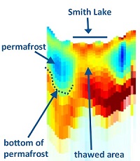
Seismic, magnetic, electromagnetic, gravity, and ground penetrating radar data can be used for many engineering geology applications, such as infrastructure support, building materials, hydrology, and geohazard mitigation. The DGGS collection of airborne magnetic and electromagnetic data can be used to identify permafrost, faults, depth of fill, fill type, depth to water table, and changes in rock type when a resistivity or magnetic susceptibility contrast is present. Electromagnetic data is useful for identifying subsurface fresh water resources. Detailed gravity surveys can provide depth-of-fill information, which is useful for infrastructure planning and understanding hydrology. Seismic methods can be used to determine fill depth and to learn more about the mechanical properties of the subsurface materials. Ground penetrating RADAR can be useful for shallow assessments, such as determining roadbed thickness.
Several of our data products are usable without specialized software by a wide range of audiences. The data in our collection can also be used as good teaching material. For some users, we may have data collected right in your own "backyard." Learn more about the data available and explore our interactive map to see what data might be in your area of interest.
General Inquiries
Email: dnr.dggs.geophysics@alaska.gov
Logan A. Fusso
Geophysics Program Manager
Phone: 907-451-5060
Email: logan.fusso@alaska.gov

Eric I. Petersen
Geophysicist, Geophysics Program
Phone: 907-334-4408
Email: eric.petersen2@alaska.gov