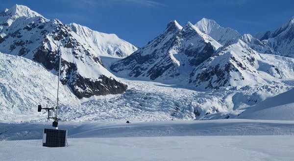
High elevation weather station located next to glaciers in the Alaska Range enables scientists to accurately monitor weather factors that cause changes in the glacial environments. Photo credit: Gabriel Wolken, DGGS.
Numerous glaciers and icefields currently occupy many of the mountains ranges in Alaska, and the processes of glaciation and deglaciation have influenced much of the Alaskan landscape.
Glacier change, is a major driver of geologic hazards in Alaska. Much of Alaska has been conditioned by the processes of glaciation and deglaciation, and recent changes in climate are causing Alaska's glaciers to melt faster than most places on the planet. These long- and short-term changes can generate a range of conditions, such as unstable discharge, glacier lake outburst floods, glacier and slope instabilities, erosion and sedimentation, iceberg production and surges that can impact infrastructure and threaten public safety.
Valdez ice-dammed lake in fall 2013. Photo credit: Gabriel Wolken, DGGS.
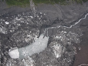
Glacial lake outburst floods (GLOFs) refer to the rapid release of water from a glacial lake due to the sudden failure of an ice or moraine dam, or to water overtopping the dam as a result of displacement waves caused by mass wasting of nearby unstable slopes. Outburst floods can be incredibly destructive. Depending on the released volume and the downstream topography, outburst floods can cause extensive damage to infrastructure and threaten public safety.
CCHP published an ArcGIS Story Map about their monitoring program of glacial lake outburst floods in Alaska.
CCHP works with partners to provide real-time monitoring of some of the most dynamic and potentially destructive ice-dammed lakes in Alaska. We currently monitor ice-dammed lakes at:
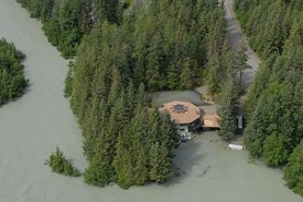
Extensive flooding from the Suicide Basin glacial lake outburst flood in July, 2014. Photo credit: Eran Hood, UAS.
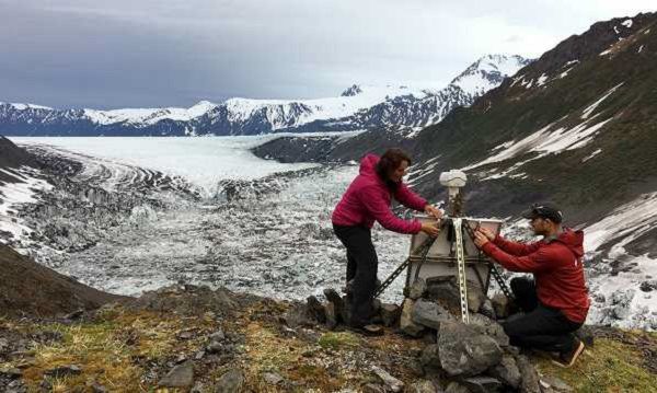
Collaborators from University of Alaska Southeast and USGS maintain a weather station in Suicide Basin. Photo credit: Eran Hood, UAS.
Outburst floods from these ice-dammed lakes have threatened public safety and damaged property and infrastructure. Our work at these ice-dammed lakes includes photogrammetric surveys and installation of remote viewer cameras, weather stations, and water level gages, which allow us to estimate stored water volume and potential outburst flood magnitudes, monitor outburst events in real-time, and provide valuable information to local authorities.
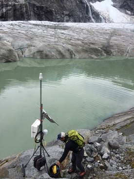
Installation of a remote viewer camera with collaborators (Kenai Fjords National Park) at Bear Glacier ice-dammed lake in the Kenai Mountains. Photo credit: Gabriel Wolken, DGGS.

Spring field-work on West Fork Glacier in the Alaska Range. Photo credit: Gabriel Wolken, DGGS.
CCHP and the University of Alaska Fairbanks (UAF) conducted a multi-year hydrology study of the upper Susitna drainage basin as part of the pre-licensing process of the Susitna-Watana Hydroelectric Project, supported by the Alaska Energy Authority (AEA). This study focuses on understanding the impacts of changes in the cryosphere on water resources by modeling the effects of future climate variability and change, permafrost thaw, and glacier wastage and retreat on runoff.
The study combines field measurements of glacier mass balance, snow accumulation, runoff, meteorology and computational modeling to provide estimates of recent historical and future runoff into the proposed 81 km2 and 63 km long reservoir. (Co-Investigators: Regine Hock, GI/UAF; Anna Liljedahl, WERC/IARC/UAF; Andrew Bliss, GI/UAF)
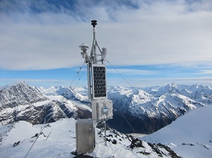
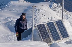
Weather station located above Valdez Glacier, eastern Chugach Mountains, at an elevation of 1829 meters above sea level. Photo credit: Gabriel Wolken, DGGS.
Scientists rely on weather and climate information to help monitor changes in snow, ice and permafrost and to develop predictive models of changes in the cryosphere. Weather data in Alaska are generally acquired from stations near towns, most of which are located at low elevation. This leaves high elevation areas of the state under sampled, which has a major impact on our ability to assess, monitor and predict change in the cryosphere. CCHP is involved in a multi-agency effort to install more high elevation telemetered weather stations throughout the state.
Data from these stations are being used to inform a number of research and public service efforts, and are helping to improve weather forecasts and aviation safety by providing real-time information from data sparse regions directly to forecasters at the National Oceanic and Atmospheric Administration (NOAA). Currently, CCHP maintains three high-elevation weather stations in Alaska: Scott Glacier, Valdez Glacier and Takshanuk Mountains. View the weather data recorded at these stations.
During the last several decades, Alaska has warmed twice as fast as the rest of the United States. Alaska's glaciers are in steep decline and are among the fastest melting glaciers on Earth (see figure below). In addition to higher temperatures, one of the impacts of climate change on maritime glaciers is an increase in the altitude of the rain-snow line. As this line rises, rain falls more frequently in high-elevation settings, decreasing the amount of snow accumulating on glaciers in the winter and negatively influencing annual mass balance. In a rapidly changing climate, abrupt changes in, for example, the occurrence of glacial lake outburst floods are typical. In order to improve adaptation and mitigation strategies that lead to reduced risk to communities and infrastructure, CCHP's works to identify and predict the frequency and magnitude of new hazards that result from climate change's impact on our glaciers in Alaska.

Cumulative climatic mass balances (kg m-2) for glaciers in five regions of the Arctic, and for the Arctic as a whole (Pan-Arctic). Mean balances are calculated for glaciers monitored in each region in each year and these means are summed over the period of record. Glaciers in Alaska have been in steep decline since the late 1980s. Source: Wolken et al., 2017; State of the Climate in 2016.

Glacier mass balance measurements on Valdez Glacier. Photo credit: Gabriel Wolken, DGGS.
Gabriel J. Wolken, Ph.D.
Climate & Cryosphere Hazards Program
Program Manager
Phone: 907-451-5018
Email: gabriel.wolken@alaska.gov
Katreen Wikstrom Jones, M.Sc.
Climate & Cryosphere Hazards Program
Hydrologist
Phone: 907-451-5010
Email: katreen.wikstromjones@alaska.gov
Malcolm R. Herstand
Climate & Cryosphere Hazards Program
Instrumentation Specialist
Phone: 907-451-5010
Email: malcolm.herstand@alaska.gov