We are coordinating a Channel Mapping Project (CMP) to systematically and efficiently map the bathymetry (depth) of rivers, as well as their velocities, using sonar, LiDAR, and ground-penetrating radar systems. These maps are essential to predict turbine performance, and are useful in a variety of engineering applications, including channel migration and flood hazard mitigation. Large-scale bathymetry mapping has never been accomplished for the majority of Alaska's rivers. By taking this step, DGGS will provide baseline bathymetric data to support numerous scientific, management, and economic objectives.
River or channel bathymetry describes the depth or 'terrain' underneath the river. Bathymetry is essential to determining a river's hydraulic and geometric properties (i.e. flow velocity, width, depth, turbulence). Bathymetric data serves as the foundation for 2-dimensional and 3-dimensional hydraulic models needed for assesing turbine perforance. The maps produced by DGGS will aid in site selection and suitability analysis for various turbine models and configurations, allowing communities to select the optimal turbine and deployment location to address their energy needs.
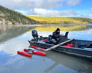
Water moving at a speed of 5 to 10 feet per second (1.5-3 meters per second) creates the ideal condition for hydrokinetic electricity generation. Due to the Alaska's climate and topography, different river reaches create different amounts of power density. We are mapping flow velocity accross large portions of the State's rivers using Acoustic Current Doppler Profilers (ADCPs). These measurements and maps will provide a quantitative way to estimate power site-specific power generation, allowing for more reliable and cost-effective turbine deployments.
In Alaska, river ice plays a crucial role in the seasonal rhythms of the landscape. The annual ice cycle shapes local ecosystems, affects transportation, and is closely monitored by communities that rely on the rivers for travel and subsistence. Seasonal ice cover has limited year-round turbine operation at a number of test sites, but we are exploring ways to overcome this challenge and produce reliable power through the cold dark winters. In many locations, there is still a large amount of energy stored in the water moving beneath the ice. We are actively monitoring ice dynamics and sub-ice conditions to provide the data necessary to unlock year-round hydrokinetic turbine operation.
Woody debris and suspended sediment in Alaska's rivers play a vital ecological role—creating habitat for fish, stabilizing banks, and supporting overall river health. However, this same debris and suspended sediment pose a major challenge for deploying hydrokinetic turbines, as large logs and floating material can damage equipment and block energy generation, and sediment is highly abrasive to turbine materials. To address this, researchers and engineers are developing debris-resistant turbine designs and protective screening systems that allow the river’s natural flow—and its ecological benefits—to continue, while safely generating power for local communities. We are actively monitoring debris and sediment dynamics to optimize turbine design and placement.
Matthew C. Scragg
Hydrologist
Email: matthew.scragg@alaska.gov


