A baseline topographic survey and installation of two erosion monitoring sites was carried out in 2019. Two time-lapse cameras and a series of staked transects were installed to monitor the shorelines adjacent to a newly built harbor and clinic. Funding for this work was provided by the Native Village of Chignik Bay. The ongoing research is a collaboration between the Native Village of Chignik Bay, DGGS, and the University of Alaska Fairbanks Arctic Coastal Geoscience Lab (UAF-ACGL).
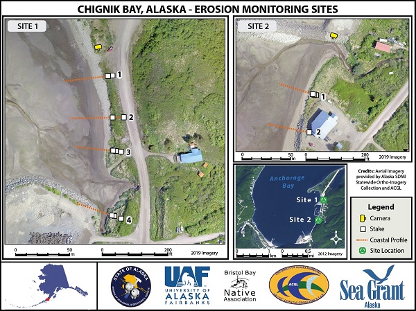
Map of erosion monitoring sites at Chignik Bay, Alaska. Each site consists of a time-lapse camera with 3-4 staked transects where local environmental coordinators take repeat measurements.
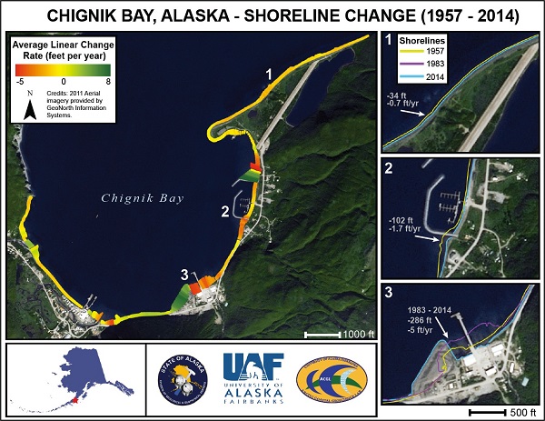
Preliminary shoreline change analysis results from Chignik Bay carried out by the UAF-ACGL. Shorelines were delineated from aerial photographs collected in 1957, 1983, and 2014. The Digital Shoreline Analysis System (DSAS) developed by the U.S. Geological Survey (USGS) was used to measure the distance between shorelines through time. Linear regression rates of shoreline change were calculated.
Transects have been clipped by the shoreline change envelope (distance between the most landward and most seaward shorelines). The shoreline change envelope is colored by the linear regression rate (feet/year), where hot colors (red) represent erosion and cool colors (green) represent accretion. Linear rates are simplified and do not accurately reflect shoreline erosion and accretion at all locations. These preliminary results document some areas of erosion, predominately at locations adjacent to rip-rap armored coastlines. These erosional areas were also identified as areas of concern by the residents of Chignik Bay.


